Introduction
Bangladesh lies in the tropical region, in the southern part of Asia. It has an area of 144,000 sq. km extending between latitudes 20° and 27° North and longitudes 88° and 93° East. 23˝° latitude and 90° longitude pass through the middle of the country. It is surrounded by parts of the Himalayas in the North and the East, and the Bay of Bengal in the South. The presence of the bay and the hilly regions causes heavy rainfall in the northeastern and eastern hilly region. The country experiences most of its rainfall during the rainy season consists of May, June and July months. Other than during the rainy season, the country is struck by cyclones in March-April and October-November often. The rainfall patterns tells that the country is having plenty of rains all over its territory round the year except during dry season from December to February.Problem Statement
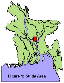
The three main rivers of the country, the Padma, the Meghna and the Jamuna, deposit a great deal of alluvial soil each year making it a mainly agricultural country. Bangladesh, a rural country, started experiencing urbanization not before 100 years. The proportion of urban population was remained only 2.43% during the period 1901-1921. After that it increased and reached 8.8% in 1974, 15.2% in 1981 and 20.2% in 1991.Study Area
Methodology
To identify the difference of the rainfall in urban and non-urban areas, both parametric and non-parametric tests were used. To check the differences over the period, the tests were conducted for 1970 and 1990. The month July was chosen, as it is the mid point of the rainy season. ArcView GIS and SPSS software packages were used for spatial and statistical calculation. The steps are as follows:Table 1: Monthly total rainfall (in cm) Station ID Station Name July'90 July'70 R209 Ruhea 558.90 749.70 R221 Thakurgaon 584.70 440.80 R206 Rangpur 307.00 476.20 R006 Bogra 549.10 532.80 R025 Pabna 367.80 387.90 R369 Noakhali 842.30 747.60 R311 Fatikchari 1057.10 1202.00 R328 Rangamati 865.40 1491.90 R260 Bhola 451.20 630.00 Source: Bangladesh Flood Forecasting and Warning Center and SWMCStep 02: Generating sample points
Table 2: Rainfall collected for sample points in cm

ID	URBAN Area	RAIN July'90	RAIN July'70

1	No	 	400.42		 484.93

2	Yes	 	413.87		 663.53

3	No	 	405.02		 449.36

4	No	 	506.36		 437.26

5	No	 	375.74		 508.37

6	No	 	390.71		 728.88

7	No	 	427.67		 507.06

8	Yes	 	420.26		 637.46
Step 04: Computing the p values
Results
Descriptive statistics of the samples say that the sample in urban areas have a mean of 411.67 with standard deviation of 10.46 for July'70 and have 618.18 mean with 76.9 standard deviation for July'90. Samples in non-urban areas have 404.35 mean value with standard deviation 35.65 for July'70 and have 626.43 mean value with standard value of 132.32 for July'90.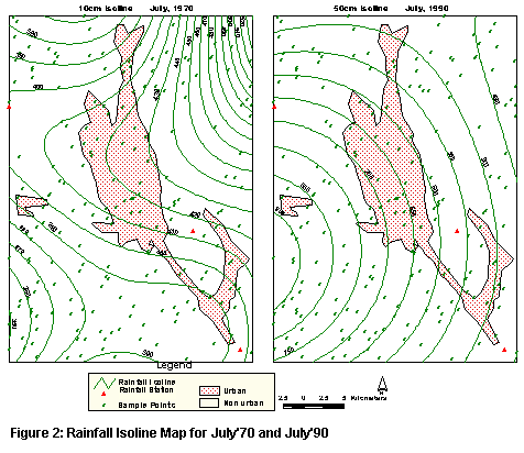
Table 3a: Independent 2 Samples Test Results		Table 3b: Wilcoxon Rank Sum Test Result

		  t	p value						  Z	p value

July'70		-2.236	 0.027				July'70		-3.542	0.001

Jult'90		 0.496	 0.621				July'90		-0.084	0.933
In t test "Equal variance assumed" option was chosen as, in ANOVA (Analysis of Variance) test, F values are around 1 and p values are high (for July'90: F = .13 and p = .719, for July'70 F = 1.56 and p = .212) which strongly infer not to reject null hypothesis, that is the variance are equal.
Conclusion
Although there is a hypothesis that the rainfall varies between urban and non-urban areas, in this study shows two different scenarios – one matches with the hypothesis, the other does not. Rainfall in both years not only shows different statistical results, it also shows different, almost the reverse rainfall pattern when the isolines were drawn. In 1990, Bangladesh had a severe flood, 1 in 100 year flood. Because of this or other climatic factors (like late or early monsoon or extreme rainfall) may influence to come up with this result. This study should have looked at into further details to examine the scenarios. Finally, it is to be mentioned that the urban extent was assumed to be same from 1970-90, though the urban area has expanded over the period. Again, the results could be effected by the fact that rainfall stations' data in urban areas were not available for this study.Reference
Bangladesh Bureau of Statistics, 1991 http://home.bangla.net/ndb/ana_vol1/density.htm