Introduction
Bangladesh, a comparatively newly born country, lies in the southern part of Asia. It has an area of 144,000 sq. km extending between latitudes 20 degrees and 27 degrees north and longitudes 88 degrees and 93 degrees east. It is a small country but has a huge population of around 110 million according to the 1991 census that makes her the densest country (720 persons per sq. km.) in the world.Problem Statement
Dhaka, now the capital city of Bangladesh, has been served as capital city or central part for all economic, business, cultural and administrative activities for last 500 year with some periodical breaks. From the history it is known that people has been concentrating in or around this region.Population Characteristics of Bangladesh
Methodology
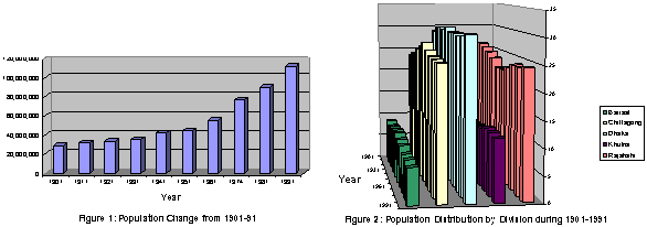
For this paper, population density data (Table 1) were available in the web site of Bangladesh Bureau of Statistics. These data were collected and use to calculate the total population by multiplying the area for each division.Table 1: Population Density (per sq. km.) by Division from 1901-1991 Divisions 1901 1911 1921 1931 1941 1951 1961 1974 1981 1991 Barisal 187 197 214 165 287 274 321 408 490 561 Dhaka 267 303 323 345 415 404 491 685 843 1050 Khulna 171 171 173 179 205 209 261 394 478 570 Rajshahi 218 233 240 244 273 271 343 502 612 759 Chittagong 146 165 178 199 244 253 294 402 487 589 Source: Bangladesh Bureau of StatisticsArcView GIS software was used to calculate the spatial center for each division. And then a GIS tool was used to calculate the spatial mean center of Bangladesh from divisional centers where population data were used as weights in the calculations. Same procedure was used to calculate the mean center for each year from 1901-91.
Results
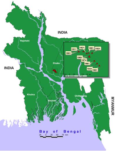
The results show that for last 100 years the mean center of population of Bangladesh is located almost at the same place. The mean shifting of the centers from their previous years is 2.94 km while the standard deviation is 1.77 km. Again standard distance of these mean centers are quite similar showing that the population distributions of these years are almost same although the population size increased a lot. Dhaka, locating by a river named Buriganga, had an advantage of river communi- ation that played a strong role in ancient Dhaka. Today it still has all those factors to make it the center point of Bangladesh not in respect of commerce but also of population.Table 2: Spatial Mean Center of Population Year Center X Center Y Standard Distance Shift from Previous Year (km) 1901 519,316.459 642,020.017 141,017.357 -- 1911 522,073.343 642,145.322 140,275.742 2.76 1921 523,895.364 640,935.813 140,060.506 2.11 1931 526,979.535 641,175.344 139,537.838 3.10 1941 529,906.374 635,115.786 139,303.830 6.73 1951 531,179.964 633,888.563 140,016.057 1.77 1961 528,317.085 636,658.685 140,112.554 3.98 1974 525,541.721 638,976.525 140,383.758 3.62 1981 525,385.007 639,423.239 140,107.160 0.47 1991 524,969.093 641,303.453 139,659.550 1.93 Total Shift = 26.47The pattern of centers movement shows that untill 1931 it moved towards east, suddenly it shifted towards south-east and came back to north-west.
Conclusion
The objective of the paper is to determine the geographic population center for Bangladesh. This was determined and was found to be around Dhaka, the capital city of Bangladesh through out the century.Reference
Bangladesh Bureau of Statistics, 1991 http://home.bangla.net/ndb/ana_vol1/density.htm